

La Florida by Geronimo Chaves and Abraham Ortelius, ca 1582-1601. Source: USF Digital Collections.
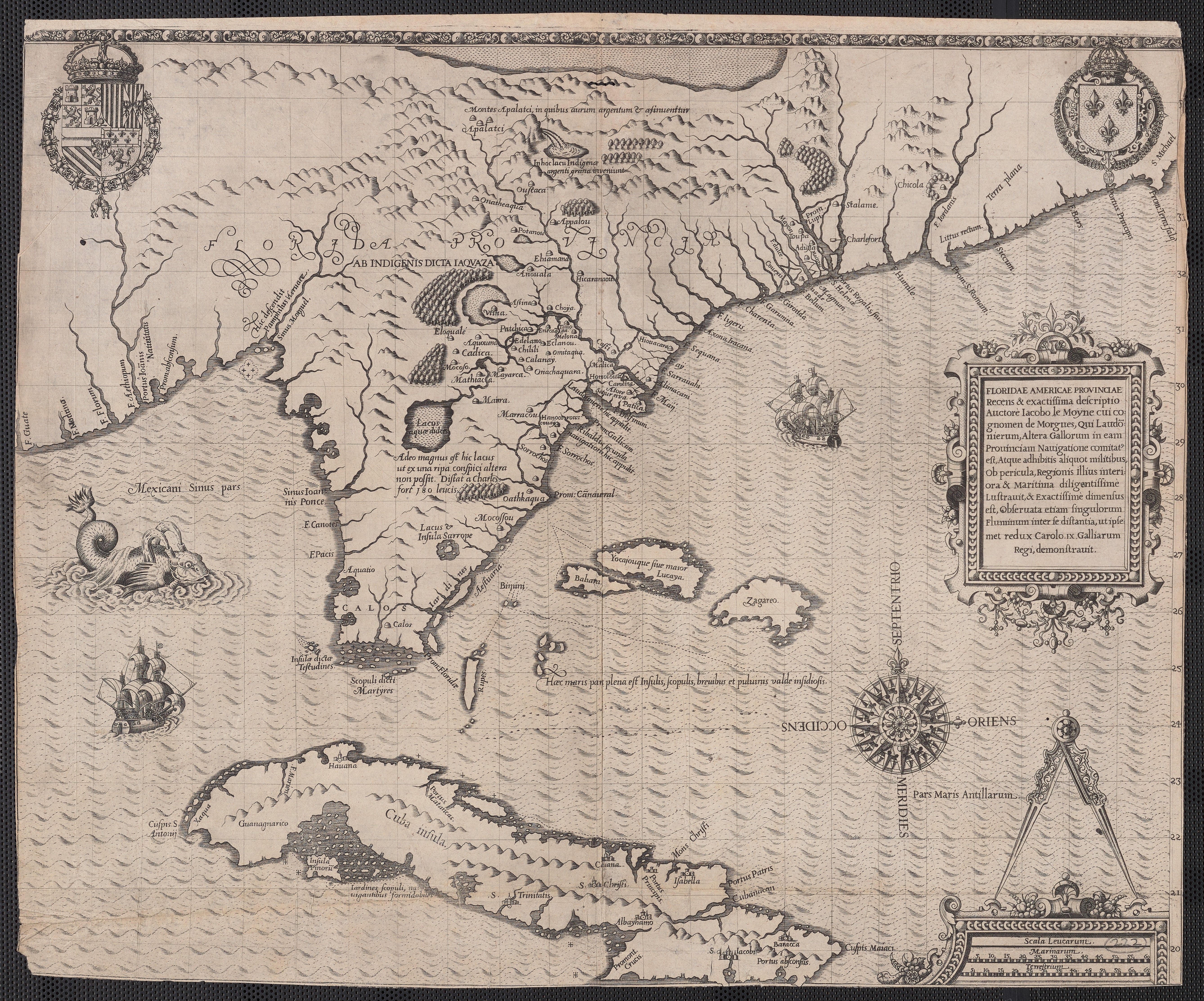
Floridae Americae provinciae by Jacques Le Moyne de Morgues, 1591. Source: Yale Library

Florida, et regiones vicinae, 1640. Source: Yale Library
 La Floride by Pierre Duval d'Abbeville, 1675. Source: BnF Gallica

Names and approximate locations of La Florida's Franciscan missions at the end of the 16th century. Source: Murder and Martyrdom in Spanish Florida: Don Juan and the Guale Uprising of 1597.

Regni Mexicane seu Novae Hispanie Ludovicianae N. Angliae Carolinae Virginiae et Pensylvanie neenom insularum archipelagi Mexicani in Amerrica Septentrionali by Baptista Homanno, 1720. Source: Biblioteca Nacional de España (via Flickr).

A map of Carolina, Florida and the Bahama Islands with the adjacent parts by Mark Catesby, ca. 1731. Source: Yale University Library.

Coast from St. John's River to Savanna, 1740. Source: John Carter Brown Library at Brown University.
 Spanish Trail Map of Florida by Archer Butler Hulbert, 1750. Source: Florida Memory.
 A new & accurate map of the provinces of North & South Carolina, Georgia &c. by Emanuel Bowen, 1752. Source: Library of Congress

East Florida by Thomas Jeffreys, 1769. Source: University of South Florida Digital Commons
 Map of the Southern Dominions of the United States by Laurie & Whittle, 1794. Source: Georgia Archives

St. John's River from the Bar to Cowford by Charles Black Vignoles, 1822. Source: University of Florida.
 Map of Florida by Charles Black Vignoles and Henry Schenck Tanner, 1823. Source: Library of Congress.
NOTE: This is the first map we were able to locate on which Jacksonville appears under that name.
 Map of Florida by John Lee Williams (1837). Source: Florida Memory

Map of the seat of war of Florida by Colonel John James Abert (1838). Source: Yale Library
 State of Florida by Joseph Goldsborough Bruff (1846). Source: Library of Congress
 Map of 1847 Jacksonville by N.R. Child, 1925. Source: History of Jacksonville, Florida and Vicinity, 1513-1924
 Map of Jacksonville in the 1850s by T. Frederick Davis, 1925. Source: History of Jackonville, Florida and Vicinity, 1513-1924

Preliminary Chart of the Entrance to St. Johns River, Florida by A.D. Bache, 1856. Source: Florida Memory

Map of the City of Jacskonville, East Florida, 1859. Source: History of Jacksonville, Florida and Vicinity 1513 to 1924

Map of Jacksonville and vicinity, Florida, showing defenses by William H. Dennis, 1864. Source: National Archives
 County map of North Carolina, South Carolina, Georgia and Florida by H.H. Lloyd and Co., Warner and Beers, 1872. Source: University of North Carolina Library
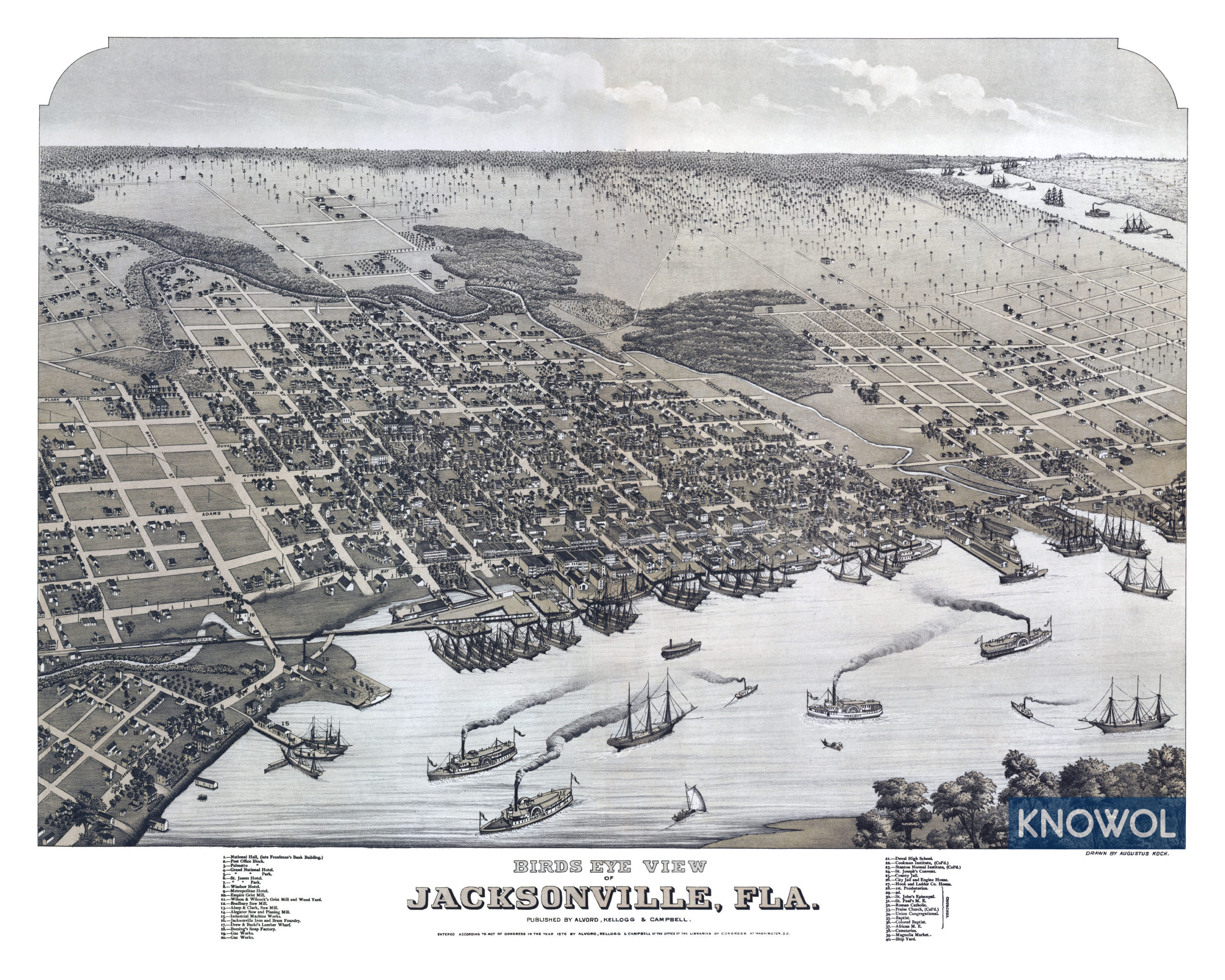 Bird's Eye View of Jacksonville, Florida by Augustus Koch, 1873. Source: Knowol.com
 Official map of the city of Jacksonville, Florida by Horace Drew, 1878. Source: New York Public Library

Duval County, Florida, 1885 by Francis Le Baron. Source: Library of Congress

Map of the city of Jacksonville and suburbs, Duval County, Florida by Francis Le Baron, 1885. Source: New York Public Library
 Map of Jacksonville, Florida by Francis Le Baron, 1887. Source: Florida Memory

Correct Map of Florida Showing the Jacksonville, Tampa and Key West System, the Tropical Trunk Line and Connections by Matthews, Northrup, & Co., 1891. Source: University of Florida Digital Collections.

Pine (Main) Street Conflagration of August 18, 1891 by T. Frederick Davis, 1925. Source: History of Jacksonville, Florida and Vicinity, 1513-1924
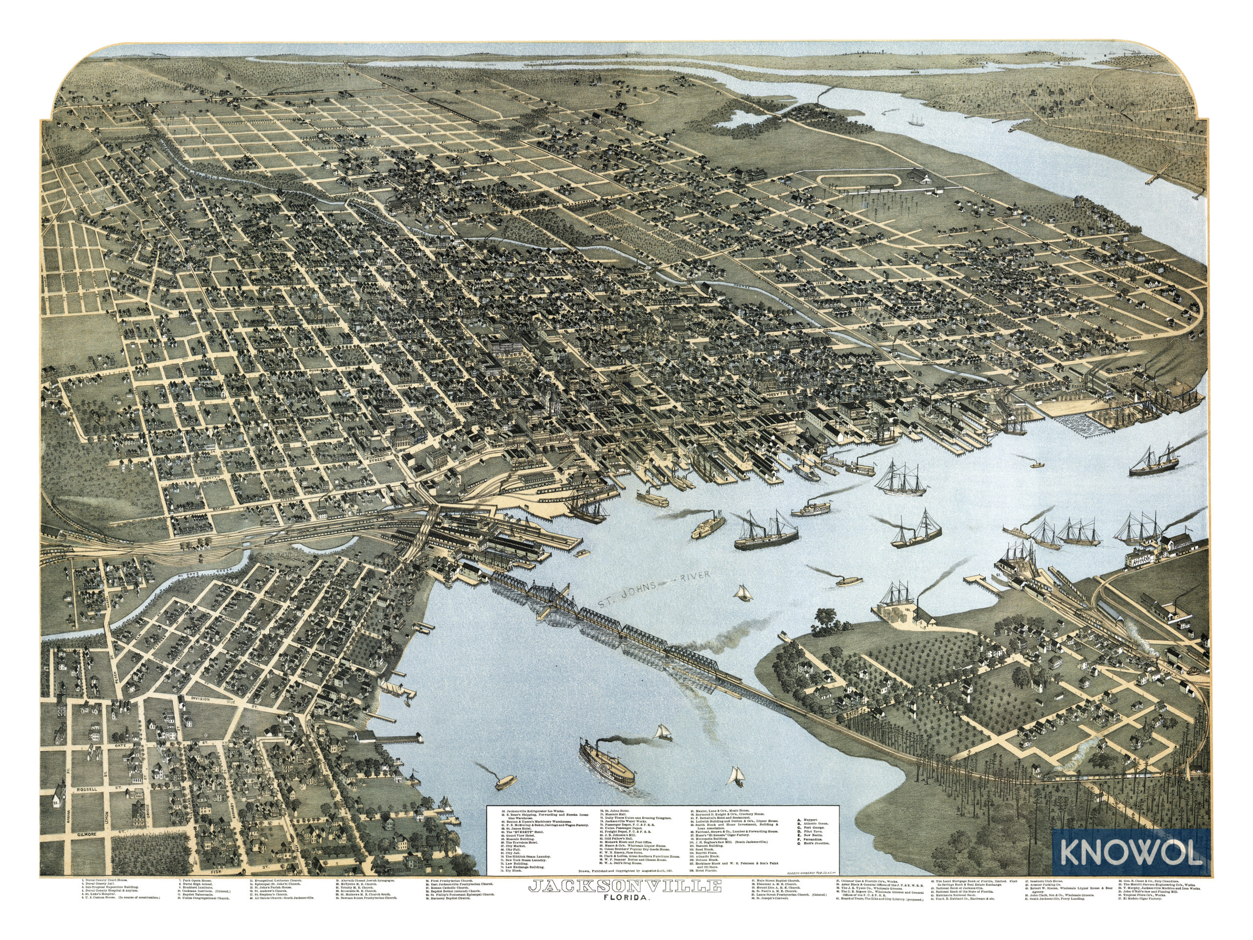
Bird's Eye View of Jacksonville, Florida by Augustus Koch, 1893. Source: Knowol.com

Map of the city of Jacksonville and vicinity by U.S. War Department, 1895. Source: National Archives

Duval County, Florida by Francis Le Baron, 1898. Source: Library of Congress

Map of district burned on May 3, 1901 by T. Frederick Davis, 1925. Source: History of Jacksonville, Florida and Vicinity, 1513-1924
 Map of Duval County by Roland Woodward, 1906. Source: Florida Memory.

Duval County by Richard J. Scott, 1914. Source: Jacksonville Public Library


Florida, Jacksonville Quadrangle by U.S. Geological Survey, 1918. Source: University of Florida Digital Collections
 Florida (Mayport Quadrangle) by U.S. Geological Survey, 1918. Source: University of Florida Digital Collections

St. Johns River, Jacksonville to the Ocean by Ellis, Curtis, & Kooker, 1925. Source: History of Jacksonville, Florida and Vicinity, 1513-1924
 Jacksonville Beach Quadrangle, Florida, 1948. Source: U.S.G.S. TopoView
 Map of Jacksonville, Florida by U.S. Geological Survey, 1950. Source: U.S.G.S TopoView
 Mayport Quadrangle, Florida-Duval County, 1950. Source: U.S.G.S. TopoView
 Jacksonville, Florida by U.S. Geological Survey, 1964. Source: U.S.G.S. TopoView
 Jacksonville Beach Quadrangle, Florida, 1964. Source: U.S.G.S. TopoView
 Mayport Quadrangle, Florida-Duval County, 1964. Source: U.S.G.S. TopoView
 Florida 1:50,000 Jacksonville by U.S. Geological Survey, 1977. Source: University of Florida Digital Collection
 Florida 1:50,000 Mayport by U.S. Geological Survey, 1977. Source: University of Florida Digital Collection.

Jacksonville, Florida by U.S. Geological Survey, 1977. Source: U.S.G.S. TopoView
 Jacksonville, Florida - Georgia, 1988. Source: U.S.G.S. TopoView

Jacksonville Quadrangle, Florida - Duval County, 1994. Source: U.S.G.S. TopoView

Jacksonville Beach Quadrangle, Florida, 1994. Source: U.S.G.S. TopoView

Mayport Quadrangle, Florida-Duval County, 1994. Source: U.S.G.S. TopoView
 Jacksonville Quadrangle, Florida - Duval County, 2012. Source: U.S.G.S. TopoView
 Jacksonville Beach Quadrangle, Florida, 2012. Source: U.S.G.S. TopoView

Mayport Quadrangle, Florida-Duval County, 2012. Source: U.S.G.S. TopoView
 Jacksonville Quadrangle, Florida - Duval County, 2021. Source: U.S.G.S. TopoView

Jacksonville Beach Quadrangle, Florida, 2021. Source: U.S.G.S. TopoView

Mayport Quadrangle, Florida - Duval County, 2021. Source: U.S.G.S. TopoView
![]()


